The Hike to Kjeragbolten: One of Norway’s Most Epic Photo Spots
Would you stand on a boulder wedged between two boulders? Well, the hike to Kjeragbolten in Norway drives people around the world crazy for its very controversial photo opportunity.
This Instagrammable spot is definitely not for the faint of heart, but is truly one of the most stunning spots in the country. Would you dare to take the risk?
After researching a ton, and speaking with locals, we still had spots many unanswered questions before reaching the hike to Kjeragbolten. "How do you get to Kjerag", or "how long is the hike to Kjeragbolten?", and mostly importantly: "Is Kjeragbolten safe?". We now have all the answers, and this guide is going to cover everything you need to know in order to hike Kjeragbolten, so you can safely get that dream shot.
*Please note that this blog post may contain some affiliate links, which we make a small profit on, at zero cost to you. Links are only used on products & services that we've used and believe in, to give you the best buying experience. Purchasing from these links helps us to continue providing free travel guides for you- so thank you for your support!
Our Travel Planning Recommendations
 Skyscanner (flights)
 Booking.com (hotels)
🎫 Get Your Guide (tours)
 Ticket Master (events)
📸 Best Buy (equipment)
🚗 Rental Cars (car rentals)
 Train Line (train tickets)
 Bus Bud (bus tickets)
 Direct Ferries (ferries)
 Cruise Direct (cruises)


📍 Where is the Hike to Kjeragbolten?
The hike to Kjeragbolten is located in the south of Norway, which a Scandinavian country in the north of Europe.

Kjeragbolten is located in the south of Norway.
🏘 What is the Closest Town to Kjeragbolten?
The closest town to Kjeragbolten is Lytebotn, which is a small town along a fjord, just 7 km from the trailhead.

Lysebotn is the closest town to the hike to Kjeragbolten.
✈️ What is the Nearest Airport to Kjeragbolten?
The nearest airport to Kjeragbolten is Stavanger, which is about 140 km away.
You can easily find domestic flights to Stavanger from Bergen, Oslo, Sandefjord, and Trondheim. International cities that fly direct to Stavanger include Aberdeen, Alesund, Alicante, Amsterdam, Chania, Copenhagen, Esbjerg, Frankfurt, Gdansk, Krakow, London, Malaga, Mallorca, Newcastle, Split, and Varna.
Flight Tip: Using Skyscanner you can check the calendar to see which are the cheapest dates for flying to Stavanger.
Search for a flight to Stavanger:
How Do You Get to Kjerag?
The route that you take to get to Kjeragbolten, of course depends on where you are coming from. Here are the different options that you can choose from.
How to Get from Stavanger to Kjeragbolten
As the closest big airport, the easiest place to be visiting Kjeragbolten from is Stavanger. You can either book a tour, or you can go on your own. Here are the different ways to get from Stavanger to Kjeragbolten.
🚐 Book a Tour to Kjeragbolten
If you are on your own, or aren't a big hiker, then booking a tour to Kjeragbolten may be your best option. This will be the most comfortable way to do the hike, and you'll probably feel much more comfortable having a guide with you to climb the boulder.
🚗 Rent a Car
We love renting cars when we are traveling, as it allows us to have more flexibility, and stop at cool places along the way. You can easily book a rental car from Stavanger airport, and drive to the trailhead of Kjeragbolten in a little over two hours.
Keep in mind that in the GPS you'll want to put in Kjerag Parking, which is right next to the trailhead. If you put in Kjeragbolten, it will lead you to a different route.
Google Maps oftentimes will send you to take the ferry to Lysebotn, but you can also drive around instead, which is the cheaper and more direct option. If you want to drive straight there, make sure to put "avoid ferries" in the option section.
Rent a car in Stavanger:
⛴ Taking the Car Ferry to Lysebotn
If you'd rather take the scenic route, you can in fact take a ferry from Lauvik or Oanes to Lysebotn. Just keep in mind that the ferries don't run all night, and are only offered in the summer months. Here is the Lysefjord ferry schedule.
Cars cost 950 NOK, and foot passengers cost 550. The ride is 2 hours and 20 minutes, so while this won't save you time necessarily, it will be very scenic, and allow you to relax from driving and save on gas (it's super expensive in Norway!). Car ferries have both indoor and outdoor seating, as well as a cafeteria with food and drinks.
🚌 Take Public Transportation from Stavanger to Kjeragbolten
The final option for visiting Kjeragbolten from Stavanger is to take public transportation. While this option definitely takes much longer, it is a bit more budget-friendly than the other options.
In order to do this you'll need to first take a bus from Stavanger to Sandnes Sentrum Station. From there you'll have to walk to Sandnes Bussterminal Ruten (which is a 3 minute walk). Then that bus will bring you Lauvvik, where you can get the same ferry that we had previously mentioned.
How to Get to Kjeragbolten from Oslo
Kjeragbolten was our first stop on our road trip of southern Norway, and we came directly from Oslo. Renting a car from Oslo is definitely the way to go.
While it is a bit of a drive (about 7 hours), it is a scenic drive, and you can stop along the way. We decided to break up the trip by staying overnight at this adorable campsite, and then continued our drive in the morning.
It's important to note that there has been a lot of construction on the highways in Norway, and the road to Kjeragbolten was actually only open during certain hours! This was another reason that we had to break up the trip, since the road was closed during the hours that we were driving. The road was open from 7 am to 8 am, and then again from 4 pm to 5 pm.
The Hike to Kjeragbolten
Once you arrive at the parking lot, you'll have to pay for your parking, and you'll see the trail right in front of the lot, with a big restaurant to your right.

The trailhead starts right from the parking lot.
🥾 Hiking to Kjeragbolten
The hike to Kjeragbolten is an interesting one! It consists of 3 different hills, going up and down each one. It has a variety in the trail from steep areas with chains to hold onto, rocks going across water, and larger flat areas marked by rocks. We're going to break down the entire hike though, so you know exactly what to expect.
Don't have time to read the whole article and want to save it for later? Just pin it!


When you first start the hike, it is very steep, going up large boulders. There will be chains going up so that you can easily find your way up, but also to help get you up. The first big hill was the steepest one to get up, and took around 30 minutes to get up, and 5-10 to get down.

The first hill has chains to pull yourself up the hill.
After the first hill we had to cross to the next hill across wooden planks. The second hill took us another 40 minutes to get over, and that's where the emergency shelter cabin is located. This is in case there is extreme weather, or something happens to you and you need to call for help.


The shelter is about an hour into the hike.
Right past the shelter you will have to cross a river to get to the third and final hill. This hill is much flatter than the first two, which also means that you have to pay more attention to the signs in order to follow the path correctly.
The way that you'll know you're going in the right direction is to always look for the red paint marks, as well as the large rock piles along the way.


The final stretch in another 40 minutes going across large rocks, through streams, and finished off by going through a trail of snow.
Being that we visited in the beginning of the season (mid June), this may not be the case for you (if you happen to be going later in the season). There is little incline, but you'll be going in and out of rocks, streams, and potentially snow.

The final stretch of the hike to Kjeragbolten has a lot of rocks, streams, and snow.
🏁 Arriving at Kjeragbolten
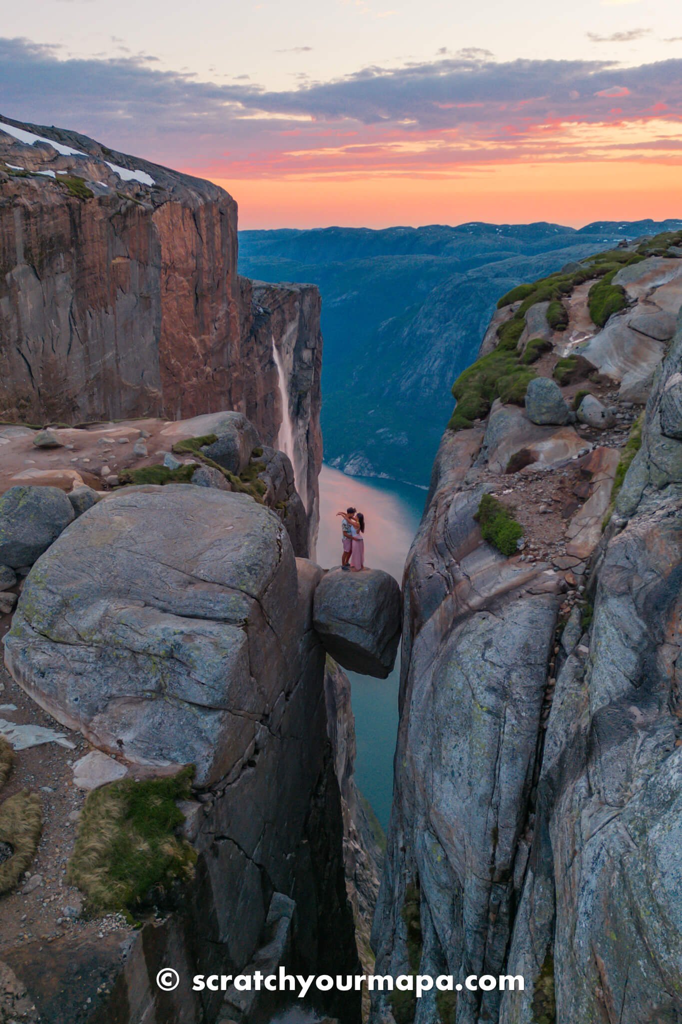
Once you arrive at Kjeragbolten, you will be overwhelmed by the sight of it! it truly is a breathtaking view. Not just the rock itself though, but also the massive cliffs around it! Walk past the rock and you will see right by the edge an insanely beautiful view of the waterfall dropping right from the top of the cliff directly into the fjord down below.
We got there for sunset, and the suns rays were reflecting right onto the cliff where the waterfall was cascading in front it. It truly was magical!


Keep in mind there are no fences anywhere, so everything the area is purely at your own risk. There is a step to get onto the boulder wedged between the cliffs, which is wide enough to get onto for 1-2 people.
When we went we were alone, but if you happen to go in the middle of the day then you may find that there will be a long line to get a photo on the infamous boulder.

😨 How Scary is Kjeragbolten?
While many hikes give an illusion of a scary edge, the Kjeragbolten boulder is just as scary as it looks. Standing on this rock is certainly not for the faint of heart, and we definitely suggest not looking down while you are standing on it.

All Your Travels
in One Book
Transform your travel memories into a unique book, with personalized pages, country by country.
Amenities at the Hike to Kjeragbolten
Along the trail there are no bathrooms, or places to get food or drinks. There is a restaurant right next to the trailhead though, in case you'd like to have a meal before or after your hike.

There is a big restaurant next to the start of the trailhead.
There is also plenty of water along the hike such as streams or small water bottles to refill your water bottle.


There are areas of water along the way to fill up your water bottle.
In addition, if there happens to be bad weather or any kind of emergency, there is a cabin for shelter that is about half way through the hike.
🏨 Where to Stay Near Kjeragbolten
If you want to spend the night near Kjeragbolten, you can find places to stay in Lysebotn, the nearest village to the start of the trailhead. Check the map below for options of places to stay:
Finally, there is a nearby campsite, if you are looking to spend a night in the area out in nature. There is also a waterfall right by it, where you can fill your water bottle before arriving at the hike to Kjeragbolten.


There is a waterfall and campsite just a few minutes up the road from the hike to Kjeragbolten.

Will You Buy Us A Coffee? ☕
As coffee lovers, we always enjoy the energy of caffeine. It helps us get the best free travel guides out there for you! 😄
Price & Timetable to Hike Kjeragbolten
Now that you know what the hike to Kjeragbolten looks like, let's go over some of the logistics.
🕘 When Can You Hike Kjeragbolten?
Kjeragbolten is open 24 hours a day, 7 days a week. Reservations do not need to be made, and hikes can be done at your leisure.
💵 How Much Does it Cost to Hike Kjeragbolten?
As far as payment goes, you do have to pay for parking on site. It is 300 NOK (about $30 USD) to park in the lot at the start of the trail.
Alternatively, you could park in either one of the camping lots outside of Kjeragbolten. One is located up the road, and the other is on the way to Lysebotn, 2 km down the road.
If you are going from the one up the road, it will tack on an hour and a half to your walk, and if you are parking down the road near Lysebotn then it will add a 25 minute walk uphill to your walk.
How To Travel Cheaper and Better in 15 minutes!
How much more would you travel, if it costed you less resources?
With our Free eBook, you will learn how to save money and time on your future trips. Plus, you'll see the exact system we use.
Grab your copy for free when you sign up for our newsletter 👇

Is Kjeragbolten Safe?
We aren't going to lie to you- Kjeragbolten is definitely a risky place. There are no barriers to ensure that you won't fall, and if you fall, it is off of a giant cliff.
Certain spots along the hike can also be quite steep, so it's important that you are physically prepared, and use the chains along the way to help you up.
When you approach the boulder, don't get very close to the edge, as it does decline the closer you get when facing it from the cliff. When we were there, there was snow, which made it riskier to slip, as well as harder to see where the cliff actually dropped off.

The boulder is scary, but it is overall safe if you are careful with your step. Just don't do anything silly like attempt to jump or do crazy stunts. We were able to both safely fit on the rock, without fearing our lives too much.
If this is something that makes you uncomfortable, then we would suggest simply enjoying the view from a safe distance, and also to not miss out on the view of the waterfall that is right past the boulder.
🧗🏻 Has Anyone Fallen From Kjerag?
There are no people that have been reported to have fallen off Kjeragbolten, so let's keep it that way!

Want To Learn How To Get Paid To Travel?
We'll teach you everything you need.
Other Things to Keep in Mind for the Hike to Kjeragbolten
Now that you know how the hike to Kjeragbolten works, and how to get there, here are a few other things to keep in mind.
☀️ Weather Conditions at Kjerag
The weather conditions at Kjerag can definitely be tricky. When we were driving from Oslo, we experienced clear skies and super hot temperatures (in mid June). It seemed that the entire journey would be like this, but we actually had very different conditions upon arrival.
As soon as we got to Kjeragbolten the warm temperatures dropped, and there was suddenly an intense storm, including hail! We couldn't believe how the hot and sunny day had turned so quickly into such an intense storm. Luckily, we got there a bit late, and were able to wait out the storm, unlike some other hikers that got stuck in the intense winds and hail.
We suggest checking the weather for the town of Lysebotn so that you can be prepared for the weather that the area is going to expect. In addition, even if it is the middle of summer, you may experience snow, so you'll want to be prepared for this as well.


🌅 The Best Time to Hike Kjeragbolten
We visited right before sunset, and it was simply magical. Due to where the sun was hitting, the cliff where the waterfall is turned bright orange, and really made going at this time something extra special.
In addition, there were no crowds at all! For you to have an idea, we started hiking at 8:15, getting to Kjeragbolten at 10:15 pm.
We would suggest leaving a bit earlier, as we are fast hikers, and the lighting started being golden about an hour into the hike.

The sun was already starting to set in the middle of our hike.
We started hiking back at 11:15, and about halfway through it was getting a little dark. We could still see, but it would have been ideal to leave a bit earlier. In our opinion, the perfect time to start your hike to Kjeragbolten would be 7:00, planning to get back to the parking lot between 11 pm and midnight.
🎒 How to Prepare for the Hike to Kjeragbolten
Here are some of the things that you should bring to hike to Kjeragbolten:
- A good pair of sneakers or hiking shoes
- Light jacket for the top (if you are visiting in summer at night)
- Tripod to take the pictures if you are alone
- Sunscreen (if you are hiking during the day)
- Reusable Water Bottle (we use this water bottle from Cafago because it is insulated)
- Steripen (if you run out of water and want to get water from the waterfalls)
- Insta 360 X3 with the extra long selfie stick for drone-looking shots
- Sandwich or snacks
- Power Bank (we use Anker power banks as they are super long lasting and durable)
- Camera (we use the Sony A7Riii)
- Standard Lens (we use the Sony GM 24-70)
- Wide Lens to capture great panoramas of the area (we use the Sony GM 14 F1.8)
- Telephoto Lens to capture a close-up of the cliff (we use the Sony GM 70-200)
- Tripod to get pictures while no one is around or for multiple shots from far away (We use the Rangepod Tripod)

Looking To Travel Somewhere?
Off The Beaten Trips is our travel agency.
But this isn't anything like you've ever experienced before. You'll have an epic trip without having to break the piggy bank.
Unique locations. Epic adventures. Lifetime memories.
Tips for the Hike to Kjeragbolten
Here are a few tips for making the most of your hike to Kjeragbolten!
- Utilize the chains to keep from slipping.
- Follow the red T marks at all times.
- Don't get too close to the edge.
- Step with care onto the Kjerag boulder and don't attempt stunts like jumps or twirls.
- Bring layers for the top, as it is windy.


Travel Planning Tools
Here are some useful tools that you can use for planning your upcoming trip!
So are you ready for one of the most epic hikes in Norway? While it is definitely one of the scariest hikes we have done, it was also one of the best!
Want to know more awesome things to do in the area? We have a lot of other Norway guides coming up! Make sure to subscribe to our newsletter so that you can stay in-the-know about new content, and receive exclusive discounts on our products and services.
Want to plan an unforgettable trip through Norway? It can definitely be tricky, but we're here to help! Scratch Your Mapa offers travel planning services that guarantee you to save money and time. Take a look at the different travel planning packages that we offer, and shoot us an email for a free consultation of the trip you'd like to book.

Here are also some other articles you'll love:
Like this article? Please share it with your family and friends, so that we can continue to keep creating free travel guides for you! It takes just a second, and would mean the world to us. Thanks for being here!